
6-9-13: The river has cut a 10-m-deep canyon through the May 31 debris flow deposit. Dave is standing on the surface of the 5/31/13 deposit. Click to enlarge any image. Chris Magirl photo.
For updates and related posts, type ‘Nooksack debris flows’ [no quotes] into the search box at right.
Report of a site visit on Sunday, June 9, by Dave Tucker (MBVRC) and Chris Magirl (USGS-Tacoma). Both of us contributed to this report. More trips will be made. Links to other posts and videos are in red.
New video is posted here on YouTube. Compare this with the June 5th video. Both were taken from about the same place.
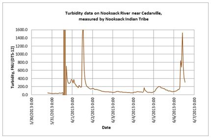
Chart showing spikes in Nooksack turbidity on May 31, June 1, and June 6. Courtesy Nooksack Tribal Fisheries.
Debris flows continue to descend the Middle Fork Nooksack River. Profound erosional changes occurred in the time since the preceding visit on June 5. More on the May 31 flow is posted here on this blog. The initial debris flow activity was caused by a landslide from a glacial moraine into the river at the terminus of the Deming Glacier. We found a deposit post-dating the big one of May 31. This one was probably on June 6 when another big spike in river turbidity occurred. Perhaps the continued activity is from more slides, or from high-water mobilization of May 31 deposits during high snow melt.

This 14′ high boulder was deposited by the 5/31 flow, and is right up against the bank. Photo taken 6/5. Compare with next photo.
We made preliminary measurements to determine the volume and extent of the

The same boulder after the June 6th flow toppled and rolled it downstream about 50 feet. It is now well out from the bank.
main flow, and walked much of its length. Among the most important or startling findings:
- Debris flow hazard remains. People should stay out of the river channel, or be ready to RUN up the bank into the forest to escape a new one. Always be alert for unusual noises coming suddenly from farther up the valley!
- Much of the May 31 deposit is already eroded away by high water due to snow melt.
- The river has cut a 10-m-deep canyon through the debris flow deposit upstream of the Ridley Creek trail crossing.
- Because of this rapid erosion, the geologic record of these type of events is probably very incomplete. There may have been many of these events over the decades, but their deposits are now entirely eroded.
- The May 31 debris flow extends 5.6 km (3.4 mi), nearly to the Elbow Lake trail crossing.
- Beyond 5.6 km, hyperconcentrated flow continued for an unknown distance (more on this below).
- The June 6th debris flow was forceful enough to topple and move a 14-foot-high boulder photographed on June 5th.
- Mud pits at least 1-meter-deep remain in the river channel hidden by seeming solid gravel and cobbles. These can be hazardous, especially to children, but hard for anyone to get out of.

Note the mound of mud in the background of this June 5th photo. Compare with the next.

Between June 5th and June 9th, erosion revealed that the ‘mound’ was a 12′ tall boulder.
Based on Nooksack River turbidity data recorded by the Nooksack Tribe near Nugent’s Corner, three distinct debris flows occurred: 5/31 was the biggest; a second, smaller debris flow occurred on 6/1; another occurred on 6/6 that was similar in size to the 6/1 event. This 6/6 event occurred after Dave’s first visit to the site (on 6/5). Here are the turbidity data from the Nooksack Tribe (thanks to Jean Snyder and colleagues there). Since measuring turbidity starting in 2009, the largest spike in turbidity before this event was in October 2009.

The top of the bank at extreme right is the surface of the May 31 flow. The June 6th flow left a light-colored ‘bathtub ring’. Most of that deposit was stripped by erosion by June 9.
We had a laser range finder and measured simple cross sections. The largest cross-section of the 5/31 event was taken 250 m upstream of the Ridley Creek trail ford, where the cross-sectional area was 220 m2, the width of the debris flow across its top was 35 m, and the mean depth was about 9 m. The super-elevation here was 4-5 m (meaning it ‘banked’ off one valley wall at a curve, and the left trimline is higher than right trimline).
What is ‘hyperconcentrated flow’? Once a debris flow has lost sufficient momentum and thickness, the boulders drop out. The fine-grained sediment continues to surge downstream at a lower velocity. This type of flow deposits gravel, sand, silt and clay as it loses energy. Deep mud pits remain until the deposit has dewatered.
- Ony 100 m upstream of the Elbow Lake trail ford, the debris flow left behind large blocks as it transformed to hyperconcentrated flow. These blocks had been floated in the debris flow.


[…] Debris flow update: https://mbvrc.wordpress.com/2013/06/12/more-debris-flows-in-middle-fork/ […]
By: Middle Fork Nooksack debris flows- another one, and an update | Northwest Geology Field Trips on June 12, 2013
at 14:20
You have such a cool job! This is really impressive.
Sincerely, Michel Sent while phone-roaming
By: MVekved on June 12, 2013
at 21:52
Michel,
If only people got paid to do this! MBVRC and the filel work we do is 100% volunteer because it is so much FUN!
Dave
By: magmatist on June 14, 2013
at 15:18
I was up there on June 2nd before any warnings had gone out. I noticed how rough and muddy the river was running. The area around the banks had thick mud that looked almost safe and dry to step upon, but it was really just thick deep goo that probably would’ve just sucked you in had you tried. I did notice quite a bit of damage in the area, figured it wasn’t worth trying the trail and just left.
By: Herby on June 16, 2013
at 21:02
Wow, that is the earliest visit we know of. Do you have any photos?
Dave
By: magmatist on June 17, 2013
at 07:26
Mother Nature at work! Do not mess with that kind of Power.
Amazing,Simply amazing.
By: James. Mcallister on June 17, 2013
at 06:44