Posted by: magmatist | August 20, 2016

Mount Baker Geology Guide Book by Dave Tucker

Northwest Geology Field Trips

Dear friends,

P1020914 Glassy margin of a 300,000-year-old dike along the Ptarmigan Ridge Trail.

I am working on my next book, a road and trail guide to Mount Baker geology. The book focuses on volcanic geology. Most of the road and trail description drafts are done. Now I need VOLUNTEERS before the snow flies to field check distances, descriptions, and get back to me with your comments. It would be helpful if you had a GPS receiver but not essential. To volunteer, leave a comment or email me:  dtchico    at       gmail     dot    com  to request a pdf of one of these:

Middle Fork Nooksack Road and Ridley Creek Trail to Park Butte Lookout

Mount Baker highway to Heather Meadows and Artist Point.

Trails in that area: Bagley Lakes Trail [1.3 mile loop]; Chain Lakes Loop starting in Heather Meadows; Chain Lakes Loop starting at…

View original post 106 more words

12770 mark

A field trip to the Easton Glacier terminus.

The field trip is FULL! Thanks to all our supporters. There is a short wait list.


Sign up for a Mount Baker Volcano Research Center field trip to the terminus of Mount Baker’s Easton Glacier.

The date is Saturday, September 10, 2016 and the trip will occupy most of your day. Meeting times and places are given below. The cost is $75, payable in advance. This covers your transportation by 15 passenger van, a paper describing features likely to be observed, and the leadership and spilling-over knowledge of not one but TWO guides!

ONLY  SIX SEATS LEFT!

This is an intermediate level trip that

12774 mark

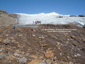
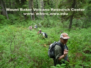
The approach to the glacier moves through the deglaciated area along the stream. No trail.

involves hiking partly on trail but also traipsing along a braided stream channel, which means walking on loose boulders, cobbles, and up (then down) a moderate rocky slope that can be a bit unstable for your footing. The total distance walked will be approximately  6 miles and the elevation gain is about 2,200′ (same loss).

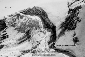
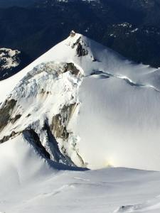
What will you see?  The Easton Glacier is one of the big ice streams on Mount Baker and has been studied fairly extensively.  It has advanced and receded like all glaciers do, and you will  be able to see ample evidence of both processes. If conditons warrant it, you will be able to go right up to the terminus to touch the ice, although don’t expect it to be pristine clean ice! We will see lava flows from two volcanoes, and tephra from three volcanoes, Little Ice age glacial moraines, and a Sherman Crater lahar.

12763 mark

Hiking cross country to the glacier terminus.

To register: Make payments to MBVRC via our PayPal page . Send an email to mountbakerresearch  at   gmail    dot   com to reserve your seat(s). As a nonprofit educational and research organization, these field trips are our primary means of raising funds. MBVRC is an entirely volunteer organization. We will also have our popular tee shirts for sale ($20 each). Once you have registered, you will receive rendezvous information.  This trip will likely fill up in a couple of days, so if interested, don’t hesitate!

Your co-hosts are Doug McKeever and Dave Tucker, both of whom are board members of MBVRC and geologists with considerable knowledge of Mount Baker.

What to bring: daypack, lunch, beverage, sunscreen and sunglasses, repellent,  clothes for the weather (our trips go rain or shine☺) , sturdy shoes or boots. Recommended are trekking poles, camera, perhaps binoculars.

This trip will fill up, so if interested, don’t hesitate!
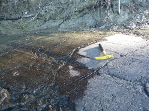
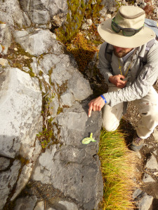
Posted by: magmatist | July 28, 2016

Flight over Boulder Glacier Debris Flow

2016 Boulder Glacier DF 7-28-16  6 25% mark

The May 25th debris flow left a dark streak the length of the Boulder Glacier. View looking west. Click to enlarge

by Dave Tucker, MBVRC

Thanks to Bellingham pilot Maureen Briggs for flying me around Mount Baker today in her Beachcraft Bonanza. The goal was to get photos of the debris flow that descended Boulder Glacier May  25th.

2016 Boulder Glacier DF 7-28-16  3 crop mark

The release zone just below the summit of Sherman Peak. The ice wall is around 100 feet high. Click to enlarge.

The debris flow left a you-can’t-possibly-miss-it streak of mud and rocky debris the full length of the glacier. The debris flow began as a snow and ice avalanche at 10,000′ on the north flank of Sherman Peak, the high point on the south rim of Baker’s active Sherman Crater. The avalanche scoured the complete thickness of the snow pack and into the underlying loose rock debris. It transformed into a debris flow and slid down the glacier as a slurry of snow, ice, water and rock fragments for 3.75 km (2.25 mi) to the glacier terminus at about 4800 feet.

As the ice and snow component in the flow

2016 Boulder Glacier DF 7-28-16  4 crop mark

The plugged east breach of Sherman Crater. A large fumarole has melted a hole in the crater glacier at top right. Click to enlarge

continue to melt, the rock portion becomes more prominent.  The east breach of Sherman Crater remains plugged with large ice blocks from the avalanche.  This is NOT a lahar, as it was not spawned by volcanic activity, and initiated in snow and ice rather than in volcanic deposits.

2016 Boulder Glacier DF 7-28-16  8 crop mark

The receding terminus of the Boulder Glacier, mantled by remnants of multiple debris flows accumulated over the years.

The 2016 debris flow was featured in a front page article in the Bellingham Herald June 13, 2016. attracted lots of attention Debris flows initiate every few years in the same place and run down the Boulder Glacier. Go here to read a report on this website about these hazardous events.

Posted by: magmatist | June 15, 2016

NEW EMAIL FOR MBVRC

Western Washington University has pulled the plug on our old email server. Please send all email to Mount Baker Volcano Research Center to our new address, and update your contact for us. Sorry for the inconvenience, its a real pain for us. You don’t have to do anything to retain your sub to this blog.

mountbakerresearch  gmail copy

Posted by: magmatist | June 8, 2016

More on Boulder Glacier debris flow

2016 scurlock 163414197.NXsFXm1s mark

Overview of the May 25 2016 Boulder Glacier debris flow. Photo courtesy John Scurlock.

John Scurlock flew around Mount Baker today (June 7th, 2016) and got some great photos of the latest Boulder Glacier debris flow. Also, seismologists Steve Malone at Pacific Northwest Seismic Network and Jackie Caplan-Auerbach at WWU went back and examined seismic records and independently discovered the timing: the initial ice avalanche began at 2:00:30 PM May 25th.

2016 scurlock 163414199.4O6c1Kn2 mark

Release scarp on north flank of Sherman Peak. Ice debris blocks east breach of Sherman Crater. rocky debris is picked up as ice avalanche scours volcanic rock below the scarp. Courtesy John Scurlock.

2016 scurlock 163414200.6kIyPN0g mark

Overview of the May 25 2016 Boulder Glacier debris flow. Photo courtesy John Scurlock.

Three seismometers picked up good records of the signal: MBW is about 6 km west of the summit, SHUK about 12 km east , and VDB about 25 km north-northeast in Canada.

2016 MBW SHUK VDB

Three seismograms showing onset of avalanche. Top to bottom: MBW, SHUK, and VDB. Vertical scale differs on each. Note long runout as debris flow descends Boulder Glacier for nearly 6 minutes.

Posted by: magmatist | June 7, 2016

Debris flow on Boulder Glacier

2016 Debris flow Boulder Glacier Corey Vannoy

June 2016. The gray streak down the center is a flow of ice and rock on the Boulder Glacier on the east slope of Mount Baker. Can’t determine from the photo how much further the debris flow extends. Sherman Peak is the pointed summit at left. Photo taken from Boulder Ridge around 4600′ elevation. Thanks to Corey Vannoy for this view. Click to enlarge images.

Reader Corey Vannoy reports a recent debris flow that swept down Mount Baker’s Boulder Glacier. He climbed this route over the weekend (June 4-5, 2016) and sent two photos. There have been no other reports of this event. If anyone else has descriptions or photos, either from the ground or aerial, please send to MBVRC. This may be the first Boulder Glacier debris flow since October 2013.

2016 Sherman Peak initiation zone Corey Vannoy

June 2016. Release zone on the north flank of Sherman Peak on Mount Baker. Periodic ice avalanches extend to rock below, which is incorporated into a debris flow that sweeps down the Boulder Glacier to the east (left). Compare with photos from other years in the link in the text. Photo courtesy Corey Vannoy.

mountbakerresearch  gmail copy

reach MBVRC via email

Debris flows initiate every few years in the same place on the north slope of Sherman Peak. Go here to read a report on this website about these hazardous events.

8594 cropped mark

The Schreibers Meadow cinder cone, south flank of Mount Baker, seen from the north. Click to enlarge.

THIS TRIP IS FULL!

The North Cascades Institute is offering a one day geo field trip to the Schreibers Meadow cinder cone on the south flank of Mount Baker. The trip is on Saturday, June 18, and is led by Dave Tucker, one of MBVRC’s directors. The trip includes bus transport from Sedro Woolley and a trip hand out.

Registration: http://ncascades.org/signup/programs/geology-cinder-cones-and-crater-lakes

The cinder cone is the best-preserved in the northern Cascades, a complete, isolated little hill containing to lakes in the unbreached, double crater. The hike to the cinder cone is 2 miles round trip, with little elevation gain until the end. Just up the trail from the parking lot we hike 1/4 mile cross country through the boggy huckleberry-covered Schreibers Meadows, then steeply up through the old growth for 100 feet or so to the forested rim of the cone. It is not for everyone- you will need to be able to get up and down the steep timbered slope through bushes. You will need sturdy shoes, good leather or heavy fabric gloves, trekking poles and sack lunch.

P1000877 rsz mark

Short bit of brush on the way to the  Schreibers Meadow cinder cone.

The field trip will also examine cinders and the lava flow erupted from the cinder cone, including a portion of the flow that flowed under water in the Baker river valley.

Neil Gilham  IMG_3742 mark

A peek at the lava erupted from the Schreibers Meadow cinder cone.

For more info, contact NCI or Dave Tucker: tuckerd  at   geol  dot wwu  dot edu.

Posted by: magmatist | April 22, 2016

Sign up for Geology Field Trip: Whidbey and Fidalgo Islands

May 14th, 8:30-4:30

TRIP IS FULL. THERE IS A WAITING LIST. To get the earliest crack at future trips, please subscribe to MBVRC RSS posts via email- in the margin at right.

IMG_4475

The view from Mount Erie, once a magma chamber below an oceanic volcano.

Mount Baker Volcano Research Center announces a guided geology field trip. This is a geologic smorgasbord, with stops near Anacortes on Fidalgo Island including ophiolite rock at Washington Park, Mount Erie’s drive-up summit, Rosario Beach and Rosario Head, and Deception Pass. Proceeding to  Whidbey Island we will visit at a minimum West Beach and an ill-sited development on the beach at Swantown.  The trip will be led by Doug McKeever, geology professor (emeritus) at Whatcom Community College, assisted by Dave Tucker, Research Associate with Western Washington University Geology Department and author of Geology Underfoot in Western Washington. Both are board members of MBVRC. COST is $75 per person (prepaid). Proceeds go to the MBVRC research fund.

IMG_4351

Doug McKeever and field trippers examine rock structure.

Van transportation will be provided, and a printed guide describing the most important geologic features of the stops. No hammers, please. Please bring a lunch, beverage (no alcohol please), and shoes and clothing suitable for a short beach walk and for the weather. Trip will “go” rain or shine.

13786 Washington Pk

Glacially polished mantle rock at Washington Park

Credit card: please go to the MBVRC donation page and put $75 in the ‘donation amount’ at the top [please feel free to contribute more, donations are tax deductible]. Make payment to the MBVRC account using our email: research  at  mbvrc.wwu.edu   Make payment to the MBVRC account using our email: research  at  mbvrc.wwu.edu You don’t need a Paypal account to do this.

Check: If you prefer to pay MBVRC directly, please send a check right away to order of MBVRC to 708 13th St, Bellingham, WA 98225. If you choose this option, please reserve via email immediately to research  at   mbvrc.wwu.edu. Will hold your spot as long as we can while your check is in transit.

This is a repeat of a trip we sponsored in spring of 2014. That trip filled very quickly so don’t delay to sign up!


Posted by: magmatist | February 2, 2016

Mount Baker presentations

ERUPTION HISTORY AND FUTURE HAZARDS OF MOUNT BAKER

2014 Feb 27a Big Lake C. Farrow mark

Feb. 27, 2014 gas plumes. Photo by Chris Farrow, Big Lake, Washington

These MBVRC events are free and open to all. Presentations by Dave Tucker. Fundraiser T-shirts will be available, $20.

February 18, CONCRETE, 7 PM, at the Concrete Theater.

March 3, BURLINGTON, 7 PM, Public Libary.


Author talks

GEOLOGY UNDERFOOT IN WESTERN WASHINGTON [Dave Tucker].

GUWW coverSNOHOMISH Saturday February 20th, 2 PM, Sno-Isle Public Library, 311 Maple Ave., Snohomish, WA

TACOMA Thursday February 25 Kings Book Store, 218 St Helens Ave Tacoma, WA. Time TBA: http://www.kingsbookstore.com/event/2016-02

DARRINGTON Saturday March 12th, 1 PM, Mountain Loop Books and Coffee, 1085 Darrignton St.

BREMERTON Wednesday May 4th, 7 PM, VFW Hall, 9981 Central Valley Road, Bremerton WA

SEATTLE, ORCAS ISLAND–Stay tuned for details

Posted by: magmatist | December 3, 2015

Geology Underfoot author talk in Burlington December 9

Dear friends,

GUWW coverThere will be a presentation by Dave Tucker about his book, Geology Underfoot in Western Washington, at the Burlington Library Wednesday December 9th at 6:30. The book is written for a general audience. The talk lasts about an hour, and will focus on the story behind the book, a sample reading from a chapter relevant to the Skagit area. Books will be for sale after ($24) as well as the stunning poster based on the cover art ($15).

Posted by: magmatist | September 6, 2015

Displaying this website on a mobile device

I don’t have a smart phone. If you do, this website may not display well on yours. You can fix that. Bring up this page on your device, and scroll all the way to the bottom. There will be an option to ‘display full website’ or something to that effect. Tap that, and voila, the website will look like it is designed to on a desktop, with all the tabs. Much easier to find your way around. OK, so maybe I’m just a troglodyte [thanks to Spiro T. Agnew for popularizing that wonderful word back in the 1970s] and everyone knows how to do this. But I suspect some folks don’t because they have mentioned this to me. Give it a try.

Your semi-luddite friend.

Dave

GUWW coverGEOLOGY UNDERFOOT IN WESTERN WASHINGTON NEWS: If you don’t follow my North West Geology Field Trips website you haven’t heard about some upcoming talks I’m giving about my book, Geology Underfoot in Western Washington. Cruise on over to https://nwgeology.wordpress.com/my-book/  and check it out.

Posted by: magmatist | June 30, 2015

Earthquake below Deming Glacier, Mount Baker

Map showing location of M 1.6 seismic event at Deming Glacier

Map showing location of M 1.6 seismic event at Deming Glacier

By D. Tucker 6-30-15

A 1.6 earthquake was detected Sunday June 28 at the Deming Glacier. Puget Sound Seismic Network reports it occurred at 12:19:49 PDT at a depth of 0.0 km. This is a steep icefall and collapsing ice may be the source of the signal.

It is probably only significant because it is the first seismic signal from Mount Baker since November 12, 2014.

 View Event Page

Magnitude: 1.6
Time(UTC): 2015/06/28 19:19:49
Time(Local): 2015/06/28 12:19:49 PDT
Depth: 0.0Km (0.0miles)
Event Id: 61035442
Network: UW

Dear friends,

GUWW coverGeology Underfoot in Western Washington, by Dave Tucker, is now available for purchase, It is a ‘peoples’ geology guide to 22 sites in western Washington. Published by Mountain Press Publishers in Missoula. For full info, please visit https://nwgeology.wordpress.com/my-book/

Order one from your local bookstore, or direct from the publisher:

http://mountain-press.com/item_detail.php?item_key=690

Posted by: magmatist | May 6, 2015

Geology Underfoot reading in Bellingham

The official release of Geology Underfoot in Western Washington!!!!!

Please come help me celebrate the book’s release!!!  Tuesday, May 12, 7 PM, Whatcom Museum Rotunda Room, Bellingham.

Doors open at 6:30. Talk begins at 7. Get there early for a seat.

I will discuss the inside story of how the book came to be, read a very short excerpt, and sign books. Books will be for sale by Village Books, who is hosting the release along with North Cascades Institute and the Museum.

IN SEATTLE: University Bookstore, June 15, 7 PM.

Thanks to all who contributed photos and ideas, and read trial chapters.

Dave


Posted by: magmatist | April 4, 2015

Northwest Geology Field Trips website

Dear friends,

A reminder that I manage two geology web sites. You may have inadvertently signed up for the wrong one. This one, and the Northwest Geology Field Trips website. That blog is here: nwgeology.wordpress.com. I publish self-guided geology field trips there, and short primers on some basic aspects of geology. Also information about my upcoming book, Geology Underfoot in Western Washington (due in stores the end of April). Check it out! You subscribe to it in the same way you subscribe to the MBVRC blog.  Thanks, Dave Tucker

Older Posts »

Categories